It is also one of the few falls we can link to a live USGS stream gauge, so you can check how much water is coming down before you leave home.
Part of the appeal of Eastatoe Falls is that it rewards a little effort: the closer you get, the cooler the air and the louder the water, and the photos rarely do it justice.
Geology and background
What makes Eastatoe Falls special
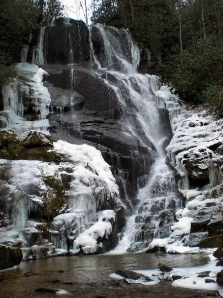
Eastatoe Falls is a waterfall in western North Carolina, on private property near the town of Rosman. It was once open to the public, and people came to see it for years. Then the property was sold, and as of 2019 the fall has been closed to the public. That closure is the first thing to know about it, and it changes how this page should be read: this is a record of a waterfall you cannot currently visit, not a guide to going there.
The fall itself is still there, on its own ground, and its neighbours are close. Claypole Branch Falls is 0.3 miles away, Pounding Mill Falls 0.9 miles away and Arrowhead Falls 1.8 miles away, so the country around Rosman holds several falls within a short distance of each other. Those are the falls to visit instead.
Do not try to visit Eastatoe Falls. It is on private property near Rosman, and it has been closed to the public since the property was sold in 2019. The coordinates above are given for reference only, so you can place the fall on the map, not as an invitation to go there.
Best time and crowds
There is no best time to visit a closed fall. A stream gauge is linked on this page, so you can still see how the water is running, but the ground itself is private and closed. If access ever changes, check the live flow and the current status before you go.
Safety
Respect the closure. Do not trespass on private property to reach a waterfall: landowners close falls because visitors have caused problems, and every trespass makes it harder for the next fall to stay open. Visit the public falls nearby instead.
What to bring
Shoes with real grip
A rain shell for the spray
Water and a snack
An offline map or screenshot
A dry bag for your phone
A bag to pack out trash
Practical tips
Do not try to visit Eastatoe Falls: it is on private property and closed to the public since 2019.
Visit Claypole Branch Falls instead, 0.3 miles away, or Pounding Mill Falls, 0.9 miles away.
Check the live gauge here if you want to see how the water is running, without going to the fall itself.
If you hear that access has changed, confirm it with a current source before you go: a rumour is not permission.
Waterfalls mark a change in the ground beneath a stream: a fault, a glacier-cut valley wall, or a band of hard rock the water cannot wear down as quickly as what lies below it.
Water flow and seasons
The stream that feeds Eastatoe Falls is tracked by USGS gauge 03439000. A reading well above the seasonal median means a fuller fall, and usually a wetter, muddier trail.
Expect the most water in spring and after heavy rain. In a dry spell, especially late summer and early fall, the same fall can look half the size.
We do not have a trail length for Eastatoe Falls yet. Some falls are a few steps from a parking area, others take a real hike, so check the park or a trail app before you set out.
Swimming is not listed. Treat the plunge pool as off-limits unless signs say otherwise: the water at the base is colder and stronger than it looks.
Facilities and amenities
We do not list a park for this fall, which often means a small trailhead or roadside pull-off with few or no facilities.
Plan as if there is no drinking water and no phone signal at the falls themselves. Use the restroom and fill your bottles before you start walking.
Fees, permits, and opening hours
No entry fee is listed. Parks may still charge for parking or day use, and federal lands often accept an annual pass instead.
Most falls are reachable from dawn to dusk. Gates, seasonal road closures and timed-entry permits are the usual surprises, so check the managing agency on the day.
How to get to Eastatoe Falls
Eastatoe Falls is in North Carolina. For the last stretch, navigate by coordinates (35.10994, -82.81726) rather than by name. Map apps often send waterfall searches to the wrong parking lot or the far side of the stream.
The final approach is usually the hardest part: narrow roads, small trailhead lots that fill early, and a walk that can be ten minutes or several hours. Download an offline map before you lose signal.
Our North Carolina waterfalls page maps every fall in the state, which helps when you are planning a route.
For the fullest flow, visit Eastatoe Falls in spring or within a couple of days of heavy rain. For easier footing and warmer air, early summer is the compromise.
Light matters for photos: the base of a fall is often in shade by midday, and an overcast day evens out the bright water against dark rock.
Crowds and timing
Arrive early or late. The middle of a summer weekend is peak time almost everywhere, and small trailheads can be full by 10 a.m.
Holiday weekends and the first warm days of spring are the busiest of all. If the lot is full, do not park on the road shoulder: it is the most common reason for tickets and towing at trailheads.
How long to spend there
Without a listed trail length, plan for half a day: enough time to find the trailhead, walk in, spend an hour at the water and walk out without rushing.
If there are other falls nearby, they are often on the same road or trail system. Two or three in a day is very doable.
Where to stay near Eastatoe Falls
We do not recommend specific places to stay. The links below search for hotels and campgrounds around Eastatoe Falls on Google Maps, so you can compare drive times from the trailhead.
Stay on marked trails and behind railings. Wet, mossy rock near the brink is the most common cause of serious injury.
Never climb the cascade or stand at the top edge, even when the flow looks gentle.
Plunge pools hide cold water, strong currents and submerged logs. Only swim where it is allowed.
In canyons, rain upstream can raise the water in minutes. Leave if the water turns muddy or starts to rise.
Leave no trace: pack out trash, stay off fragile moss and plants, and keep drones grounded where they are banned.
What to bring
Shoes with real grip
A rain shell for the spray
Water and a snack
An offline map or screenshot
A dry bag for your phone
Cash for parking
A bag to pack out trash
Practical visitor tips
Screenshot the directions and these coordinates before you leave town.
Wear shoes you do not mind getting wet: spray reaches further than you expect.
Keep your phone in a zip bag near the base.
Pack out everything, including food scraps.
Tell someone where you are going if the trail is long or remote.
Frequently asked questions
Where is Eastatoe Falls, North Carolina located?
Eastatoe Falls is in North Carolina. Its GPS coordinates are 35.10994, -82.81726.
What kind of waterfall is Eastatoe Falls, North Carolina?
Its form (plunge, cascade, horsetail and so on) is not listed yet.
How tall is Eastatoe Falls?
Its height has not passed a source check yet, so we do not show a number or include it in tallest lists.
How much does it cost, and when is it open?
No fee is listed, though parking or day-use fees may apply. Most falls are open dawn to dusk; check the managing agency for seasonal closures.
Is Eastatoe Falls good for families?
It depends on the trail, which we have not confirmed. Check the length and terrain first, and keep children well back from wet rock and the edge.
How do I know if it is flowing?
Check USGS gauge 03439000 for today’s streamflow, and the last three days of rain in the weather panel.
The bottom line
Eastatoe Falls is worth a detour, especially after rain. Go early, check recent rain, wear grippy shoes, and give yourself time to sit and listen once you get there.
Waterfalls nearby
One fall rarely fills a day. These are within about 40 miles.
Leave a waterfall report