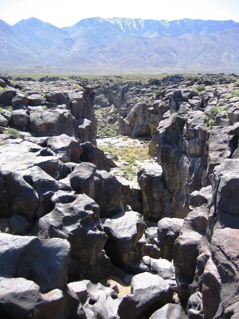
What makes Fossil Falls special
Fossil Falls is a unique geological feature in the Coso Range in Inyo County, California. It is a waterfall shaped by fire and ice: volcanic activity in the mountain range, along with meltwater from glaciers in the nearby Sierra Nevada, played a role in the creation of the falls. The rock here was polished and cut by water running over fresh lava, and the result is a smooth, dark, sculpted channel that looks nothing like an ordinary stream bed.
The falls are located near the community of Little Lake, 1.0 mile off US 395 on Cinder Road to Red Hill, with signs to Fossil Falls. It is a desert fall, reached from the highway rather than through forest, and the black basalt against the dry hills is the whole view.
Its nearest falls are a long way off. Salmon Creek Falls is 29.7 miles away, Seven Teacups 32.2 miles away and South Creek Falls 32.6 miles away, so Fossil Falls is a drive-to destination rather than one stop on a crowded trail. The geology is the destination.
Source: Wikipedia
Geology and background
Fossil Falls was shaped by two forces. Volcanic activity in the Coso Range laid down the lava, and meltwater from glaciers in the nearby Sierra Nevada cut through it. The water polished the basalt into smooth, rounded forms, carving a channel through rock that was still young in geological terms. The fall is a record of that meeting: fire made the rock, ice water shaped it.
Plan your visit
Getting there and parking
- GPS: 35.9701145, -117.9088168 — Get directions
Navigate by coordinates rather than by name. The falls are 1.0 mile off US 395 on Cinder Road to Red Hill, with signs to Fossil Falls. Download an offline map before you lose signal: this is desert country, and reception is not guaranteed.
Best time and crowds
No stream gauge is linked to Fossil Falls, so recent rain and runoff are your best guides. Flow follows rain and snowmelt in the Coso Range. Expect the most water in spring and after heavy rain, and the least in a dry spell.
This is a quieter fall than the famous ones, and the desert setting keeps crowds thin. Even so, an early start is the best way to have the viewpoint to yourself, and to avoid the midday heat.
Safety
Stay on marked trails and behind railings. The basalt here is smooth and slick when wet: never climb the cascade or stand at the top edge, even when the flow looks gentle. The desert is hot and dry, so carry more water than you think you need. Plunge pools hide cold water, strong currents and submerged logs.
What to bring
- Shoes with real grip
- Extra water: this is desert country
- A rain shell for the spray
- An offline map or screenshot
- A dry bag for your phone
- A bag to pack out trash
Practical tips
- Follow the signs from Cinder Road to Red Hill: the falls are 1.0 mile off US 395.
- Look at the polished basalt in the channel: it is the clearest geology on the page.
- Screenshot the directions and these coordinates before you leave town: signal is thin out here.
- Carry extra water and sun protection: there is little shade in the Coso Range.
Keep exploring
- More waterfalls in California
- Explore California waterfalls
- Salmon Creek Falls (29.7 mi away)
- Seven Teacups (32.2 mi away)
- South Creek Falls (32.6 mi away)
- Explore the map
Leave a waterfall report